US Apologises Over AI-Generated Africa Map Blunder
US Apologises Over AI-Generated Africa Map Blunder
By Divine Macaulay ·
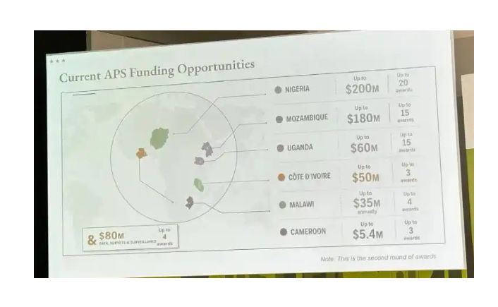
The map, shown during a session on new U.S. global health agreements, incorrectly relocated Nigeria and several other African countries, prompting widespread backlash after conference attendees shared screenshots on social media.
The United States Department of State has apologised after an inaccurate, AI-generated map of Africa was displayed during an official presentation at the AIDS 2026 conference in Rio de Janeiro, Brazil, sparking criticism over glaring geographical errors.
The map, shown during a session on new U.S. global health agreements, incorrectly relocated Nigeria and several other African countries, prompting widespread backlash after conference attendees shared screenshots on social media.
One of the most glaring mistakes depicted Nigeria as a landlocked country in the Sahara Desert instead of on the Gulf of Guinea. Mozambique was misplaced in the Horn of Africa, while Côte d'Ivoire was shown on the opposite side of the continent.
A review of footage from the conference showed the map carried an OpenAI watermark, indicating it was generated using the company's artificial intelligence tools. OpenAI said it is investigating how the image was produced.
The erroneous slide first gained attention after AIDS policy expert Emily Bass published screenshots on her Substack newsletter. The images quickly spread across LinkedIn and other social media platforms, drawing widespread criticism over the apparent lack of verification.
Matt Petit, an Atlantic Council researcher specialising in artificial intelligence and geopolitics, said the incident reflected a failure of basic quality control.
"Whoever created and approved this slide did not know where countries in Africa are and did not care to check their work," Reuters quoted him as saying.
In a statement, the State Department accepted responsibility for the error and apologised to conference participants and African partners.
"We take full responsibility for the confusion and misrepresentation it caused for attendees, including our African partners," the department said.
According to U.S. officials, the faulty map was inserted during last-minute revisions by a staff member shortly before the presentation.
The presentation was delivered by Jeff Graham, the senior U.S. official overseeing the President's Emergency Plan for AIDS Relief (PEPFAR), Washington's flagship global HIV/AIDS initiative. Graham did not respond to requests for comment.
Despite the controversy, the State Department said the conference produced productive discussions and reaffirmed the United States' commitment to global HIV/AIDS programmes.
The incident comes as Washington continues to reshape its foreign assistance strategy. Although key components of PEPFAR have resumed following disruptions linked to a policy review under the Trump administration, the U.S. is scaling back funding for HIV prevention, disease surveillance and other public health programmes, including plans to phase out the initiative in South Africa.